
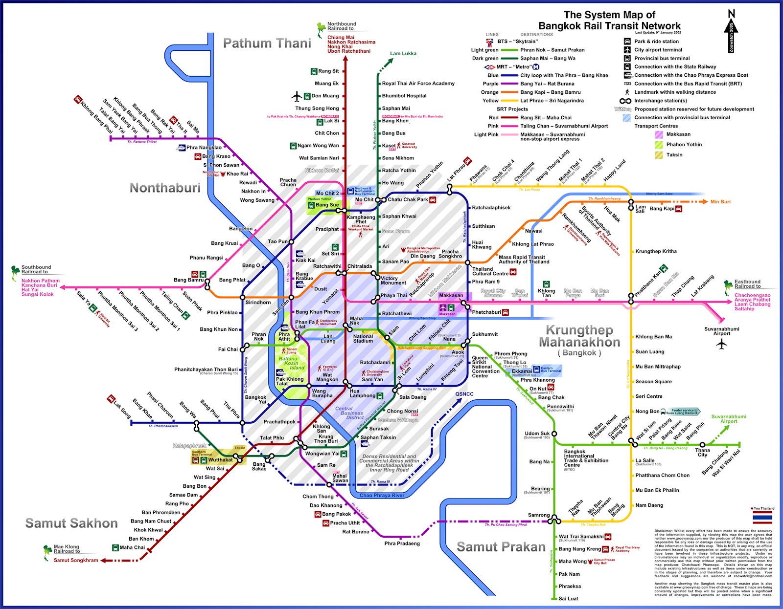
Over the past few years I’ve become quite interested in what lies behind the scenes in Bangkok, most especially the plans for the city’s transit system. The existing train routes are embarrassingly inadequate for a city the size of Bangkok, but there are big plans in place. For years now I’ve been trying off and on to find a good map that lays it all out in a realistic fashion, but it’s been difficult. So, I decided to make my own damn map on Google Maps based on a combination of maps, diagrams, and websites across the web.
The most frustrating thing for me is that any map you’re likely to see online is a colorful candyfloss expanse of straight lines and right angles. There are very rarely any roads mentioned, the map is not to scale, and the lines it displays don’t follow the actual routes they’ll take, more like the rough direction they’ll go. Here’s an example:
Click to embiggen!
See, it looks nice and gives you a rough idea of what to expect, but it doesn’t follow any real roads or natural lines and doesn’t tell me anything about exactly which roads will be serviced by what new routes. The more I searched, the more I found – even an art project by artist Wit Pimkanchanapong called “If There Is No Corruption” which imagined what the city’s rail network would look like if scheming bureaucrats didn’t dip their fingers into the pie at every turn (thanks to my buddy James at Nomadic Notes for that one).
So, I decided to make my own map.
First, I looked at a ton of maps online and took note of all the similarities. Then, a buddy of mine who works at the Department of Transportation directed me to the websites of each of the routes. In true Thai fashion, each proposed line has its own management, its own strategy and its own website. And, again in true Thai fashion, the websites are almost all pretty awful, with broken links, outdated information, and even the odd spinning gif straight out of 1992. In case you were wondering, they are: Orange Line, Blue Line, Purple Line, Dark Red Line, the Grey Line, and Light Red Line, for which the domain has expired. Actually, a few of the websites were not bad, but it still took me a long time to navigate to the maps section, figure out what was where, and match it up with a Google Map. Of course, as I don’t read Thai that well, it’s entirely possible I was missing the one high-res, newly-updated map page, but I’m not holding out hope.
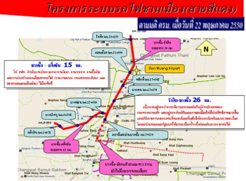
Thanks for the easy-to-read details, Red Line website! (actual resolution)
So by looking at random images from the web and comparing that to the maps I found on each line’s website, I was able to plot a map on Google Maps. Then it was just a matter of zooming in and adjusting the fine details. Of course, it may well be that some of the routes I included are cancelled, out of date or inaccurate, but I think that, considering all the maps I looked at, it should be a pretty good overview of what Bangkok will look like in 10 or 15 years. Assuming rampant corruption doesn’t sink the whole thing (coughHopewellcough).
And of course, as soon as I finished writing this post, my friends at BK Magazine scooped me with their own story on the upcoming transit lines and had their own map. It’s well worth a read, and they have some routes on their map that I’ve never seen before, but again, it’s all straight lines and right-angles, so it’s hard to tell where exactly they’ll go.
Anyway, I’ve embedded the map below, where you can zoom in and drag it around and see exactly where things will (probably) end up going. I was going to go in and include all the stations, but even I don’t have that much spare time.
Click here to open the full-size version.
Also, I’m still not entirely sure which parts will be above-ground, on the ground, or underground, or a mix of all three. Well, that’s not entirely true – one of my favorite sections can actually be zoomed in on – the tunnel where the blue line will emerge from underground after going under the river near Pak Klong Talad (the flower market):
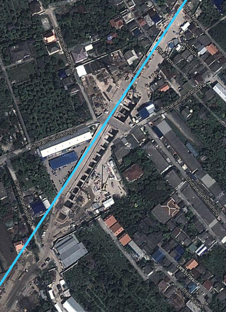
Unsurprisingly, the guards at this site aren’t too happy about random foreigners trying to ride their bikes into the tunnel. Uh…so I’ve heard.
It also happens to be right on one of the bike routes I ride, so I’ve been able to follow the progression over the past few years.
Anyway, that’s the likely rough plan for Bangkok’s train lines over the next decade or so. Did you notice anything I got wrong or additions that can be made? Let me know!
interesting information.
thanks for the hard work
wonder whar will eventually really get done
Thanks Tom. Yeah, the BK Magazine story has a timeframe, but we know how Thailand works. Many of the bigger lines are already being built so I’d say by 2015/2016 we should see some good new options transit-wise.
Hi Greg, I am also interested in the BKK Metro and Sky/Mono Rail development.
Your Map is really good! I am actually working on a similar Map with all stations names and depots. However. The Grey Line is missing on your map.
Maybe we can share some information and complete the Map.
I am not familiar with internet links and staff. However. I know how to use the e-mail.
The question of above and underground is actually not so difficult.
Orange line is all underground.
Grey Line is elevated (Mono Rail).
Blue line south extension is partly underground and than elevated. (your picture shows the tunnel portal.
There is a lot of information in the Wikipedia and on the MRT web-page.
Partly are web-pages to the different lines existing.
However. It would be interesting to hear back from you.
Greetings
Thomas
Hi Thomas, thanks for the info. I mostly want to know if it’s underground or above ground so I know if I can take my bike on it. So far underground trains don’t allow you to. 🙁
Where is the gray line? I haven’t heard of it before. Send me a message on the contact page on my blog and we can share some more info.
Hi Greg,
I have a nice map showing the mrt/srt lines in BKK (fitting you google map – great staff!!) and a list of KM, Planned/Existing etc..
Would like to share and just wonder how to get it over to you.
Greetings
Thomas
Hi Thomas, thanks. Send me your email via the ‘Aboot’ page on my site and we can tawk. 🙂
It would be cool if it was possible to separate between (or have 4 diffrent maps that progresses)
– What exists today
– What is actually being built right now
– What is planned in the near future
– What is planned in the distant future
Anyway, great work
Is the Orange Line in your map the same as the Grey Line talked about in this article:
http://bk.asia-city.com/city-living/news/bangkok-construction-mrt-grey-line-begin-2014
Also, I’d like to mention the khlong boats, than can i.e. take you quickly to Ramkhamhaeng/Bang Kapi from Pratnunam. Not a tourist area, but sporting events (Ratchamangkala National Stadium) and several universities are located there.
Thanks Mulder. It WOULD be good to have those on the map… 😉 No time right now.
No, as far as I know, the orange line is an entirely different line, and I can’t find any map anywhere of where the gray line will go. Looking at the map I can’t see how it would get from the Rama 9 bridge to Thong Lo without cutting very close to (or through) Phrapradaeng. Let me know if you see any maps anywhere and I’ll add it.
Great work Greg! Wow, this must have taken some effort so hat-tip to you, good sir. I hope these projects do go ahead.
I have always wondered what the hell was up with the concrete pylons that go out to Don Muang, so you have answered my question I had forgotten to Google. I always figured it was a bureaucratic bungle of Thai proportions, so good to know the backstory. I have caught the train a few times to DMK and followed the pylons, wondering if anything can be built on top. Then I saw those overpasses that have been built into the path. *smh*
Thanks James! Yeah, the Hopewell project is emblematic of Thailand’s inability to get anything done without massive corruption. Hopefully at least they’ve brought it under control to the point where they can finish these train lines. 🙂
Awesome work Greg,
One small point though, I think the blue line is slightly wrong near wongwian yai. I think it should be going down tanon itsaraphap because I go on that road every day and they’re building the MRT station there?
Hi Andrew, thanks. You raise an interesting point – I’ve seen that construction too, but I’m not sure what it’s for. If you zoom in on satellite view on the map just a little bit northeast of where the two blue lines meet up on the Thonburi side (also seen in the last picture of my post), you can see the tunnel coming up from underground. If the line were to go down Itsaraphap, it would have to curve pretty sharply to the left or right, and then sharply left or right again to go under the river. And if you look at the Blue Line website map here, you can see that there’s definitely some stations planned on Itsaraphap, but not a rail line – which is weird, because they’re definitely building something there. Let me know if you find anything out – I’d like to know what that is as well.
I could of used this map a few weeks back, I like the sort of stuff I can put in my iPhone and use when disorientated.
Wow. I know this is an old post, but thanks for the awesome work. I haven’t seen most of these routes.
Any idea where we can get updated info? I know the BMTA is already floating a bond for the Orange line so it looks like that’s already moving forward.
Personally, my fingers are crossed for the southern extension to the MRT as the city’s central Sathorn / Yan Nawa neighborhoods have extremely high population density and absolutely terrible public transportation. It’s the biggest ‘hole’ in the city’s network IMHO. I have my doubts they’ll do it though. (?)
Hey James, thanks. I have no idea where one would get updated info on individual routes unless you spoke Thai and knew exactly where to look or who to call. Each of the lines has its own website and, like most Thai websites, are full of broken links, outdated info, viruses, and spinning .gifs from the 1990’s. 🙂
I know they announced the destruction of the Saphan Taksin BTS station like a year ago but so far no movement there. The MRT extension from Hualumphong is well underway and will come up in Thonburi (see a pic here: https://twitter.com/BkkGreg/status/491500559543705600)
Agree that something needs to be done in Yannawa, that whole area is just a dusty, industrial wasteland with so much potential. Boo!
Hi Greg, that map is great, thanks.
But, the Dark Red Line from Machachai, ends in Wong Wien Yai, are there plans to connect it to Hualampong? Do you have any info about that, because there is no brigde in Klong San, underground? How? It is a very old train track, trains ride with open doors, no aircon, do they have plans to renovate it?
Hey Ziko, thanks for writing. That’s a good question – the dark red line on my map doesn’t really make sense as you’re right, there’s no bridge in Klong San. I just copied this from another SRT website somewhere that assumed that one day, there would be a connecting line from the existing station at Wong Wian Yai to the existing tracks at Hualumphong. I just filled in the blanks. But if you go here and here you can see some interesting information. I’m not sure what stage it’s at now…probably delayed quite a bit due to all the political turmoil throwing things into disarray.
Hey, just downloaded your app! Thanks for all the work you are doing on the city! I can’t see what you did about the railway update, and I don’t think is on the app, any chance you can send it to me as a jpg to my email? [email protected]
Cheers,
Jeff
Hey Jeff, thanks a lot. Hope you enjoy the app!
Guys this is great information. I have been trying to determine the current and future construction of BTS and MRT lines. However the information is scarce. At some stations there is maps on the wall ,in not very high profile locations , however they are all in Thai and not easy to make sense of. I have been watching the progress at Bang Sue for some time and while progress was going along reasonabl well it seems to have slowed down recently.
Rather than emails I would like to set up a time for people interested in these projects to meet and share your knowledge. Is an one interested?
Hi Dean, I’m definitely interested. In fact, I’ve been keeping an ear out for anyone in the transit department who would like to speak at a group I co-organize, but as with most government agencies in Thailand, emails and calls go unanswered, and I don’t think we’ll ever get to hear from anyone.
One road overlooked but with at least partly the infrastructure/pylons for a sky train system is the Kaset-nawamin road. Although I have read somewhere that they would/could be used for an expressway, which would make little sense because the road down is already fully congested and any extra entrances and exits will make it worse
Thanks Rob, that’s interesting. I think Bangkok should have built subway lines back in the day instead of more highways…but hindsight is 20/20, I guess. 🙂
Great map! I’ve been following the construction for the last 7 years or so. I believe there has been talk of a light rail line that will run from either the Udom Suk BTS or Bangna BTS (I’ve seen different maps with each place as the first station) up Bangna-Trad Road before it turns north at Thana City and into the new yet to be built terminal at the airport.
Hey James, thanks. Indeed, I think the one you mean is visible on this map (https://c1.staticflickr.com/3/2813/12473114103_a58411b74c_b.jpg). But you’re right, there’s all kinds of maps, but most seem not to have it, so I didn’t include it on my version. But I plan to keep updating this as we go forward, so who knows? 🙂
Yesterday I was at the Bang Son railway station ; they build two new sky train stations and two lines are crossing one another ; on your map I can only find one of the two lines ; the second line goes to the river and I saw they are building a new bridge too next to the existing Rama VII bridge. Is this for a sky train or for a regular train connection to the south/west ?
Great map.
Hey Geert, thanks for commenting. On further searching, I think I found what you mean. Is it the Light Red Line that will go from Taling Chan to Bang Son? http://en.wikipedia.org/wiki/SRT_Light_Red_Line I think that’s it. According to the Wikipedia page it’s a light rail commuter system that was suspended in January 2013, but will open again until parts of the Dark Red Line are completed. This page also has some maps http://www.skyscrapercity.com/showthread.php?t=882032&page=119 Anyway, I added it to my map too, but not sure if it will ever be completed. TiT. 🙂
Please keep on updating the maps, especially the mono rail lines that they are doing a study on that runs through thonglo and towards the CDC area.
Also I don’t understand why they keep on building platforms with horrible designs where you can’t walk from one side to the other without needing to swipe your card. Its super inconvenient especially for the disabled / handicapped. Not only that I find the spaces on the platform too narrow as well as the trains too narrow considering the population it serves.
I’ve been to Taiwan and Seoul, their trains and platforms are all a lot wider! Not to mention the flow of passengers going up and own platforms are more efficient. Just take a look at Siam station, everyone jams up going down the escalator that it blocks people crossing the platform. They should just turn escalators into a stair way to improve the flow of traffic. They also need more signs telling people to walk on the left and stand on the right. Perhaps these are some points you can raise with government officials when you email them. Maybe someone with their heads straight can bring it up during their meetings!
Thanks Mike, but fat chance! While researching this post I sent dozens of emails, not a single one was ever returned. I totally agree that the designs are bad – they don’t seem to understand the concept of building for increased capacity. Siam/Silom/Asok during rush hour are just ridiculous, but it seems like we’re stuck with this design for better or worse. 🙁
You can’t compare educated populations in Korea and Taiwan, two of the richest countries on earth, to a place where most of the population still lives on rice farms.
People in Korea and Taiwan know how to line up in a queue. In Thailand a lot of people don’t or don’t want to. Ever wait at a pharmacy or bakery only to have some old lady jump in front of you? Happens every day in the land of smiles, but totally unheard of in Korea or Taiwan.
Until you fix this deeply embedded cultural problem you don’t get anywhere, even if you make train platforms the size of football fields.
That’s a good point Pla Lek – platforms in Beijing are miles long but old ladies will still climb over you to get through the door first. But again you seem to be working really hard to try and find something offensive. Mike’s comment doesn’t say anything about the PEOPLE of Thailand or Taiwan or Korea – only you do. He’s talking about the design of the stations.
I’m not offended, now or ever. Wouldn’t matter if I was. My point is that design won’t change anything. Other structural changes need to be made first in order to change the people.
Otherwise you’ll be casting pearls to swine.
Dear Greg
thanks for all your work to keep everybody uptodate.
I have a simple question to ask you: Close to Minburi, Sukhabiban 3 Rd or End of Rhamkhamhaeng Rd there is a company called Mistine. I am wondering if there will be any line passing and if yes where might be the closest station?
Thanks a lot in advance
Miguel Angel
Hey Miguel, if you look at my map you can see the Orange Line goes right up Ramkamhaeng. Wikipedia has a page on the Orange Line where it lists the proposed stations. Might be a few years until it’s done though. 🙂
Nothing “very Thai” about this unless you’re a racist expat who thinks everything they see in Thailand is some kind of cultural expression.
New York City has one of the most used and extensive systems in the world, one owned by several different companies. They’ve been working on the upper east side line for 70 years and still haven’t opened it. Also all kinds of failed projects, lines that were abandoned and never opened.
The BTS/MRT needs lots of improvement but is obviously world’s ahead of Phnom Penh, Yangon, Saigon and even Los Angeles California which still have no trains at all!!
Pla Lek, your insulting but very well-worded reply is a breath of fresh air! One day I hope to be able to take offense in everything I read like you do, but until then, I will have to just be happy understanding the context of things I read. By the way, I didn’t say anything was “very Thai and ONLY Thai”. Surely you have to agree that many Thai government websites are full of broken links. Surely you have to agree that the Thai government is known for its red tape and inefficiency. That’s not to say other government websites don’t suck, or that other governments aren’t full of red tape, merely an observation about Thailand.
Speaking of my own ignorance, yours is showing through quite nicely – LA has six light rail lines, twice as many as Bangkok. Mostly I know that because that’s where Tom Cruise dies in Collateral. 🙂
Sorry bro but I’m not offended. Don’t know what you read into my comment but my point was my point. When people see problems in Thailand they say “oh isn’t that so Thai” which insinuates that these are genetically ingrained into Thai people. Not only falang do this. Thai nationalists do too. They pretend there are certain immutable characteristics of Thai people. For foreigners it’s bureaucracy, corruption, stupidity. For nationalists it’s uniqueness, pure culture, independence.
In reality even the idea of “Thai people” is very new. Thailand is only a few generations old and consists of different people like Muslim Malays, Laotians, Khmers, Tai Yuan, mountain tribes, white Tai, red thai, black Thai, Suay, shan, kachin, and especially in Bangkok and among the wealthy Chinese.
So of course nothing is Thai or “very Thai “.
There is corruption, bureaucracy, etc. These things have common English words to describe them because they are not unique to Thailand or any other country but are universally known across the world, basically anywhere there is money which is everywhere.
Karate is very Japanese. That’s why every language uses the Japanese word to describe it.
Conversely there are words for bureaucracy and corruption in every language.
This New York subway line was proposed in the year 1919. It might open with limited services next year. “very thai” or all too common around the world? https://en.m.wikipedia.org/wiki/Second_Avenue_Subway
Light rail doesn’t count bro. That’s like a bus on tracks. Los Angeles has some of the worst traffic in the world and no their public transport can’t compare to the bts and mrt, let alone NYC, San Fran/ Bay area, seoul, Taipei, Tokyo, Singapore, etc.
There is a nice story of corruption and bureaucracy behind that too if you’re interested: http://www.monorails.org/tmspages/la1963.html
This is a great mapping for person who cannot understand Thai language well like me.
I was looking for this kind of map. Thanks.
Well done that man,
just back from Thailand & where we flew from Don Muang airport, noticed the extensive work going on, trying to bring Don Muang into the transport system.
Came home, trying to find out what linked with what & we all know how hard that is about anything Thai.So now I know 🙂
Surprised there’s no direct train from airport to airport, looks to Me you’ll have to change anywhere between Yomarat & Mo Chit 2, seems odd, seeing as most of us fly into Suvarnabhumi & then out of Don Muang on a low budget airline, now seems the perfect opportunity to get it right, or maybe they are & it’s just not shown.
But in any case, top man, you know when, you just need to know LOL how sad !
Thanx a million
Lee
I stay with friends in BKK who live on the border of Don Muang and Rangsit and often see the new works going on from the bus. Shortly after Don Muang (leaving the city) station the new work on the Dark Red Line veers to the left and judging by Google earth and what I have seen with my friends goes along the railway line. The Kak Hok railway station seems to be there. The Italian-Thai has its its site office there. I have not seen any signs of building in Rangsit in front of the Zeer Building as shown on your map.
For Lee — the new (Suvarnabhumi) airport was opened and Don Muang was shut but was unexpectedly reopened as a lot cost airport so I imagine that is why no link between the two was planned.
Paul
I don’t know what happened to my last post -perhaps it got moderated.
This was about what I saw when I was in BKK about this time last year.
https://www.youtube.com/watch?v=JGoZl8uYvOE
Another YouTube video if you can stay away for two hours. Most of the audio was missing when I started to see it.
https://www.youtube.com/watch?v=DKin0ms79GM
Paul
Love to see a KZM ( Google Maps overlay) for this map
Hmmm, that’d be nice. Let me think on that.
You can actually just download the kml of any public my maps, like this one:
https://www.google.com/maps/d/viewer?mid=17wcuEbeg01fc5ODY_SjzbjRt1aQ&ll=13.745304618135105%2C100.53485871214593&z=14
Just finding this post. Super helpful as I was in Bangkok in February and had a painful experience trying to navigate with an outdated transit map. I’m going back in March of 2017 and with prior knowledge, I’m trying to update maps and get a better grip on where things are. Your map is fantastic (I don’t know why all transit maps don’t have this option. I live in Chicago where our system is pretty straightforward, but coming from outside, could be confusing!)
Anyway – just a bit of thanks for all the work you put into this.
Thanks Wendy! Yes, the existing maps look pretty but don’t really tell you much about where exactly they go (a problem with most Thai websites, which use pretty hand-drawn maps that are nearly useless). I try to keep this one fairly updated – whenever I hear a new tidbit I tweak it a bit (like the new Gold Line going in along Charoennakon Road). If you’re feeling a bit geeky for rail, my buddy James just made this great map of ALL of the rail lines in SEA that are planned – but not yet built. We can dream. 🙂 http://www.nomadicnotes.com/southeast-asia-rail-map/
Looking good Greg, I was going to do this so very happy to see you beat me to it. Only addition I can think of to add would be the location of future stations, which I believe are also included in the plans (albeit maybe not 100% confirmed).
Thanks Marcus. Yeah, I actually started doing that but it quickly became clear that’s a job for a guy who’s getting paid by the hour. 🙂 Also at the time I did this, I couldn’t find any maps with English names on them, but I think they exist now.
In your Google map, the pink line (Khae Rai – Minburi) is totally different to the one in your metro style map. Is that a mixup or is it supposed to look like that?
Anyway, great work and it’s fun to dream about what could be. But I’ll believe it, when I see it 😉
Btw, Bangkok Post just had an update on some of the lines:
https://twitter.com/RichardBarrow/status/816843922198687744
Hi Florian, thanks. I saw that today and actually updated the proposed completion years on the lines that were mentioned in that article.
I’m not sure what you mean by my metro style map – there are two pink lines? Can you explain?
Dear Greg,
Your map is really good! I have been studying your map and I saw that there were some minor mistakes. You are missing some parts of the MRT light red line and the BTS light green line. The map is also missing the MRT Pink line and the MRT brown line that I believe has been approved by the cabinet. I also believe both these lines run from Nonthaburi to Northeast of Bangkok. (For more info you should read MRT Pink and Brown line articles on Wikipedia) I believe some stations names in the purple line are incorrect because I live in Bangkok and I have been on the purple line. (Opened August 6 2016)
Overall you map is good.
I know the map was made some years ago so I know that it might not have the latest information.
Anyway thanks for the map. It helped me with my research.
Thanks again
Pawat
Thanks Pawat! Glad you liked the map, but I do believe the pink line is there, connecting Nonthaburi with Minburi. Also, from what I can find online, the brown line was merged with the orange line in 2009. I try to keep the map mostly up to date, but it’s hard to do when there are so many stories in Thai and English, and some are conflicting. When the lines open, I will make sure to update the map completely. 🙂
The MRT Brown monorail line is a separate line which is still proposed to run from Khae Rai along Ngam Wong Wan rd, Kaset-Namawin rds to terminate at Seri Thai with the Orange Line. This line is not approved as yet.
You are current that the mid 00s plan for a MRT Brown line from Bangkapi to Minburi was merged to extend the Orange Line.
Also, you are missing the BMA MRT Light Blue line whichis planned from Pracha Songkro to Chong Nongsi.
Also, you could add the short privately backed Gold monorail line which appears to be close to approval.
However, you’ll find a summary list (See post #508) of all lines and extensions posted on a TV thread, https://www.thaivisa.com/forum/topic/406991-the-new-skytrain/?page=34 . A new update will be forthcoming.
Map wise, it is a great addition that you completed and you can add extra lines as they are approved.. You might want to check out Arch Students map at the bottom of that thread. Generally, the easiest one to read.
Hey LG, thanks for the info, much appreciated. I’m not sure about the light blue MRT line you mentioned – last I heard it was cancelled, or at least very unlikely?
I also have the Gold Line on the map already, from Krungton to Prajadhipok. I live in that area…not looking forward to the traffic while it’s being built. 🙁
Thanks for the link to the map too, that’s fantastic! Too bad it’s not a video that I can pause and inspect. 🙂
For the MRT Light Blue line I should have added that it is not approved yet. It is still part of OTTP future plans. Much like the MRT Brown line and 2nd stage of the BMA Grey line (which you have included but which is still just a discussion) we will need to wait until the early 2020-25 to see how the next stage of lines will unfold once current lines are completed.
Add to that the still tentatively planned BTS extension from Bearing along Bang Na -Trat rd to the airport – future T3. If and when the BTS ext from Bang Wah to Taking Chan is built there has already been discussions between OTTP & the BMA to extend it further north into Nonthabui and perhaps link up with the Purple line.
Hi Greg,
In regards to UN’s SDGs,I am currently doing a university project on sustainable transport in Bangkok, and I found your website as well as your answers to the comments very useful. I am trying to address the shortcomings of sustainable transport in the city, and I am curios to know of any recent publications. Could you recommend any?
Also, if interested, I would like to ask you a few questions by mail or in person as part of my data collection.
Best Regards
Joakim
Just found this…just a verfiable note: The red line at the north end of Don Muang Airport, follows the existing railroad right of way, veering to the northwest. I have not followed to the end, but there are stations being built. The last one I have seen is at the Rangsit (346) over cross. It is at the existing Rangsit Railway location. It does not now, nor did it in the original plan, follow the motorway, after Don Muang Airport.
Hi Jay, thanks for writing. You are indeed correct – a bit of digging and I found this site (http://www.bangsue-rangsitredline.com/data2_en.php) which has a bit more information. The route veers left after Don Meuang and followed Kampheng Pet 6. Right now the plan is only to go to Lak Hok, two stops past Don Meuang, but later stations will continue all the way to Thammasat.
The 26km SRT Dark Red commuter line (narrow gauge) runs completely along the right of way the whole way to Rangsit. It will then be extended a further 10kms (4 stations) to Thammasat Uni though that tender is not due until next year. Again along the current SRT line.
A couple of things that are important to note.
The SRTET ARL (Airport line) will be extended to DMK from the current terminus at Pahya Thai – this ext is actually 4 years late. Thus, a new 2 platform level super station is being built at DMK (4 levels in total with concourse) as part of the Dark Red line construction BUT the viaduct is not. ie. a separate will be built.
The planned HSR line from the new Bang Sue Intercity Terminal to Korat and Chaing Mai will also run along the same right of way requiring a whole new viaduct. IN summary there will be 3 different viaducts when all is built!!
Lastly, do remember that the Dark Red line will eventually be some 90kms running from Thammasat Uni to Mahachai when it is finally completed.
Hi I have seen the Dark red line extension on the map is drawn all the way to Rangsit along the elevated Don Muang Tollway. I would expect the line will follow the existing railway which means it should turn left after Don Muang Airport. I might be wrong tough. Can you please clarify. Thanks.
Hi Andrew, thanks for writing. See the above comment and my reply from Jay Hardy.
This might assist in providing some clarity of where things stand for the future network.:
A) Under construction by the end of 2017:
1) MRT Blue Line ext,
2) BTS Sukhumvit line southern ext,
3) BTS Sukhumvit line northern ext,
4) SRT Dark Red line,
5) MRT Orange line Phase 1,
6) MRT Pink monorail line,
7) MRT Yellow monorail line Phase 1.
#1 to #5 are currently under construction.
#6 & #7 have some preliminary site works underway but require some extra design. Thus, construction is not really expected to begin until the 4th quarter of 2017.
By the end of 2018, Phase 1 of #1 will open and the remainder of #2 will open – assuming no further delays..
B) Expected to be tendered in the 2nd half of 2017:
1) MRT Blue line west extension to Phutthamontong Sai 2,
2) MRT Purple line southern extension to Rat Burana,
3) MRT Orange line west extension to Bang Khunnon.
4) BMA Grey line – a small chance for late this year. More likely for 2018.
Note: #1 & #2 were already expected to be approved for tender by the end of June.
Mainly from knowing it due to having followed the whole policy debacle that is mass transit in BKK for the last 20 years.
I also update a few different Thai/bkk based sites, wiki etc with this same info.
Nice work on the maps! I’m a map fiend myself and have been trying to follow the BTS system as it grows. Thanks for the work and updates. I check back every so often and this seems to be the best source I can find.
Thanks Glenn! It’s a living project, and a fun one to update.
Saw the new extension opened, so of course had to come visit your map. Thanks again for keeping this updated!
Thanks Glenn, yeah, have to keep this up to date! Sadly, I haven’t even ridden on the purple line yet, let alone this new extension. Will have to work on that. :-/
Greg, I’ve done an update of all metro projects which you may be interested in. Available, at https://www.thaivisa.com/forum/topic/406991-the-new-skytrain/?page=44&tab=comments#comment-12599167
Note the best map to use if the one done by Archstudent posted below the update. You could perhaps post it here at the top of the page under Khun Zoowatchs 2005 map.
Thanks LG, that’s a hell of an interesting page. Things I need to add: 1) extension from Bang Wa to Borommaratchachonnani 2) Add the black line from Bang Na to SVB. However, I don’t want to get into adding all the MAYBE lines right yet…let’s just concentrate on what we have right now. 🙂
That being said – up for a sit down to chat about this map? Would love to have your expertise in helping to refine some of the lines and talk general train nerdage. Send a message via the contact form if I can buy you a pint or two. 🙂
Progress of civil works for metro lines currently under construction;
1) MRT Blue Line ext: 98.25%
2) BTS Northern ext: 63.27%
3) MRT Orange Line: 8.62%
4) BTS Southern ext: 100% – still due to open in Dec 2018
5) MRT Pink line and MRT Yellow line: still mainly preliminary site works
6) SRT Dark Red Line: 97.94%
7) Tinky toy Gold Line: still mainly preliminary site works but supposedly it will be complete by Dec 2019
Thanks for the update LG. Big changes coming. I live right by #7 and traffic in that area has already been screwed up. Big parts of the road blocked off and lotsa construction. It will sure make the opening of IconSiam ugly.
Greg, Thanks for your Living Project, it is good to see that all the Thai Governments past and present see the benefits now of rail transportation. I am in Lam Luk Ka, is it possible to add the extensions to the Northern Light Green Line Sukhimvit or is this still in the maybe stages?
Hey George, thanks for the comment. I saw that in a few different places, but beyond a few quick mentions, I can’t find any really solid info about it – no maps or dates or details. As far as I can see, they’ll “get around to it” when the extension to Khu Khot is done. According to this page, it’s schedule for 2029, but I’ll believe it when I see it. 🙂
George, the next phase of the northern section of the BTS Green Line from Khu Khut to Lam Lukka (9km, 5 stations (N25-N29) ) along Lam Lukka rd will be done once the current northern extension is opened.
Actual timing is contingent upon when it receives final Cabinet approval and the tender goes out (that was actually meant to happen earlier this year).
Two other extensions of the BTS network might come first, the last of the Green Linesouthern extension and the proposed Bang Wah to Taling Chan extension.
Also, depends on if the delayed MRT Orange Line western ext, MRT Purple line southern extension. MRT Blue line west extension are all tendered first . Note: as you can see from my 19 July 2017 post above these 3 extensions were all due to be tendered in the 2nd half of 2017.
I would expect work commencing in late 2020/or 2021 if the above extensions are tendered next year.
Great update, thanks LG!
Just clicked on the link for the orange line http://www.mrta-orangeline.net/. I got s.s.a. about the line but did get 4 option to find out about 1} Train Tickets Thailand, 2) Charter Bus Tours Thailand, 3) Thailand Flights and 4} Bus Tickets Thailand plus what appears to be a search box. When asked when the line will be finished the search gave me a black box
To be honest, didn;t expect nought else. They obviously haven’t yet learned the rolls of GOOGLE and WIKIPEDIA in today’s society.
Thanks are due to you for pulling this together.
Hey MrMo, thanks! Yeah, Thai websites…what can I say. If they work, I’m always surprised.
Hi, I cannot find where an existing train goes or comes from or stops. I live near the Makkasaan Airport link and the Petchubur MRT.
There is a train, an older one but not blue traveling East<–West. From Phaya Tai to Makaasn it travels at street level using the same property as the airport link high above it. . A long bar comes down to block traffic on Rachadapisek and it blows itts horn on approach but doesn't seem to be stopping, just riding through. I am reminded at least ten times per day of Johnny Cashes Folsom Prison Blues. Anyway, I wonder where it comes from and where it goes. IF it went to the airport, I am sure the BTS would not have built the airport link. If you know what is is and where it stops, I'd appreciate your emailing me at [email protected].
Hey Dan, I’m not sure, but sounds like the cargo line that goes from Bangkok Port out to the Lat Krabang container terminal near the airport.
Daniel, SRT passenger trains at grade level on this line are using the Eastern Line. The only pax services on the Eastern line are the;
1) Once daily Bangkok to Sattahip via Chonburi service,
2) Twice daily Bangkok to Aranyapratet (Cambodian border) service which is now running right to the border with the new 6km extension beyond Aran.
3) There are a few local services to Chachongsao not usually listed on the SRT english timetable, http://www.railway.co.th/main/index_en
Dear Greg,
Can you help me in recommending/directing me to the latest and the most accurate current/future development map of Bangkok transit (MTS, MONORAIL, MRTA SRT etc) map?
There are many but i need one that is recently and accurate.
Kind regards,
Dominic
Hey Dominic, as far as I know, this is the most recent and accurate one.
Can I get a high def quality of the first metro map? When I print it off A4 some parts are blurry and not readable..
Sorry, I don’t have any – I grabbed that online somewhere.
A few quick updates;
1) The 1st phase of the BTS northern extension from Mo Chit to Ha Yeak Lat Phrao 1.4km (Central Lat Phrao) is opening this Friday 9 August from 3pm.
That might be a little earlier once they clear up after the Opening Ceremony by PM Prayuth at 12pm, but don’t expect to use it before 3pm
2nd Phase opening: early December Ha Yaek Lat Phrao to Kasetart University (4 stations)
3rd Phase opening: Dec 2020 rest of the extension
2) MRT Blue Line extension to Tha Phra
Most should know by now that this has opened fro limited 6 hour (10am-4pm) trial shuttle service, free trial period. This will open for full service on 29 September (supposedly the whole section to Lak Song)
3) MRT Brown Line
Has been approved by the MRTA Board in June and is being designed intergrated with the N5 Expressway project.
4) Construction updates
Progress of civil works for lines currently under construction (as of 30 June)
1) MRT Blue Line ext: 100% – S&E installation: 83.19%
2) BTS Northern ext: 100%
3) MRT Orange Line: 39.29%
4) MRT Pink line: 38.20% and
5) MRT Yellow line: 37.85%
6) SRT Dark Red Line: 100%
7) Tinky toy 2.2km Gold Line: approx 38-40% est
Nice, thanks LG! Coming along nicely…finally. 🙂
Hi Greg! Thanks for the awesome map!
On the big map the BTS light green map splits up in Udom suk towards south and east. Right now it only runs directly south and not on Bangna – Trad road. Do you know if they are still planning on expanding it on Bangna – Trad, connecting it to the airport?
Hey Mark, sorry, I don’t check this blog as much as I should. I think you’re talking about the Cyan line, which – as far as I can see – is on hold for now. But they’re also building terminal 2 at Suvarnabhumi, so they’ll need a train line for that eventually…so it might be back on sometime in the future.