
When visiting friends ask me how Bangkok is laid out and what the best way to get around is, I tell them one thing: buy cards for the BTS (skytrain) and MRT (subway), fill ’em with cash, and you’re golden. Bangkok is a city that – at least since the BTS opened in 1999 – has expanded, grown and evolved very much in line with the routes that the electric trains take, as many cities do. But I also usually tell my friends that, unless they want to be particularly adventurous in Bangkok, almost everything they could need – save for a few major attractions – will likely be within 2km of the BTS or MRT. So I started to wonder – what areas does that actually cover? With the help of Google Maps and Photoshop, I decided to find out.
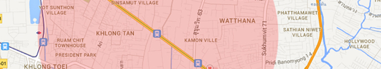
As of this post (mid-2013), Bangkok only has two BTS lines and one MRT line, but that’s changing fast. There are several new lines under construction (which I’m going to write about in a future post soon), but for now, the Sukhumvit line and the Silom line are where most of the clubs, restaurants, malls and nicer condos are located – at least the ones that most foreigners frequent. Of course, Bangkok has many, many very worthwhile attractions that are nowhere near a train line but a very large percentage of the socializing, carousing, eating, drinking and sleeping that an average Bangkok expat does goes on within 2km of the train lines. As an example, let’s look at Thong Lor station, a popular stop in a neighborhood known for it’s foreign population, among other things.
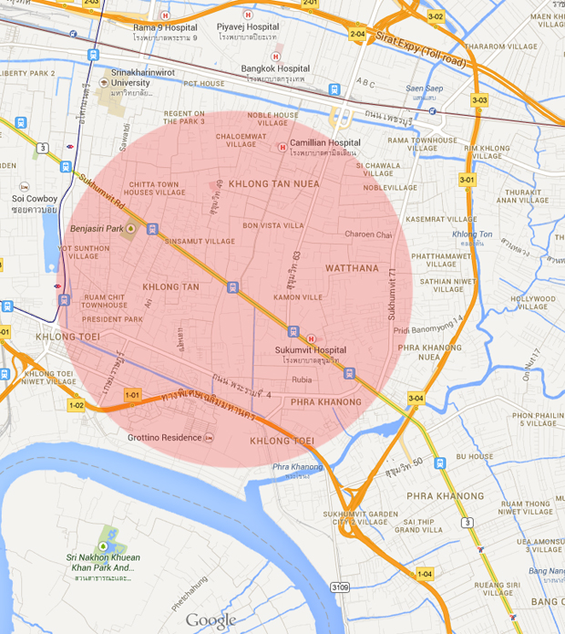
An approximately 2km radius from Thong Lor BTS station.
Of course, the only boundaries that really matter here are the top and bottom ones, as the left and right sides of the circle will expand in line with the BTS track, but I’d say this is pretty accurate. Not many foreigners I know live down by “Grottino Residence”, and ditto for the area up past Petchburi. Now let’s take a look at the entire rail network:
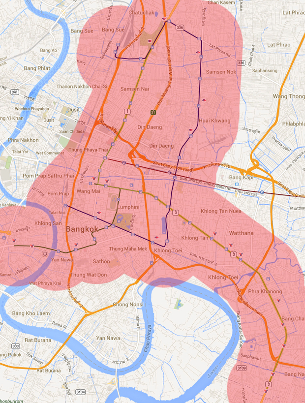
Zoomed out a bit.
Here we can see the full extent of the 2km limit, which covers a pretty wide swath of the city. Let’s zoom out a bit more:
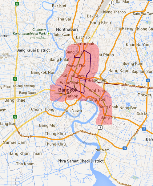
Zoomed out space station-style.
This map will look much different in 10 or so years once all the train lines are well on their way to being completed (I hope), but for now…yeah, I’d say the estimate I give my friends is about right.
If you include the express boat service on the Chao Phraya – which is same easy to use as the two railway lines and even cheaper – then you have almost all of the central Bangkok covered, including the Wat Phra Kaeo area.
A small correction – you left out the latest BTS station on the Thonburi side named Talat Phlu, now it runs right till the BRT interchange near The Mall Tha Phra. But even Google Maps does not show that station yet. I only tried BRT once when it was still free-to-ride, if you’d include that then you could add the Yannawa area to the area in pink.
Hey Andy, good call on Talat Phlu…although the area around that station is basically a wasteland right now. Things will improve as more condos go in though. Funny thing with the BRT, I’ve yet to meet anyone who has used it as anything more than a novelty. I’m going to do a follow-up post to this soon that will show the same thing but including ALL of the proposed rail lines for the future; that will look much different. Now all we can do is hope they continue with construction. 🙂
You can add me to the list of ‘people who’ve used the BRT as something other than a novelty’ – specifically, we were heading to the David Beckham temple. It’s really more to connect the residents of that area with the rest of the city, although Google Maps hasn’t yet recognized it…
FWIW, it makes a great trip for photo ops where it connects with Chong Nonsi BTS.
Very cool post! I often try to figure out where the new lines under construction are going to see if I would ever want to use them. But for lines that are already open, what about the airport link? Not that there is much to see at any of the stations (except maybe Makkasan, which is already covered by Petchaburi MRT), it seems to be used pretty heavily by Thai commuters already.
Thanks Stuart. I will be writing a new post soon that you’ll like much better – map goodness all around!
Of curiousity, I wonder what exactly is the problem with the ARL. I have never taken it.
Also, has the BTS improved since 2011? I was in Bangkok in February, and things went smooth on the BTS the time I was there. I didn’t count how many cars they have now.
Hi Mulder,
I think the problem with the ARL is just sloppy planning. The areas around the stations are generally dusty, undeveloped wastelands, and even when it connects to the subway or BTS you have to do a lot of walking, often down crappy sidewalks in 38º heat, not ideal for someone with a suitcase or two. The elevators are too small to handle big bags; access roads are small and poorly planned; there are very few bus connections; scam taxis are allowed to dominate the parking areas; etc. All of these problems were voiced by nearly everyone when it began construction, but no one bothered to listen. The bottom line is that unless your hotel is VERY close to the train line, it’s cheaper, faster and easier to take a taxi to/from the airport, so there’s no incentive. Shame.
I prefer the BTS more than the MRT, I think maybe because most of my friends live around the BTS area.
I try to live no further than 10 minute walk from a BTS station, as I don’t like using bike taxis as they pose a danger and my insurance wont cover a crash.
I really don’t see why they cant make a card that interchangeable and works both on the MRT and BTS lines. it would be really convenient for tourists and locals that have to use both lines each day. 🙂
Agree, it’s ridiculous that it doesn’t yet exist, but it’s supposedly coming later this year. Of course, that’s what they said last year…