
Ahhh, the new year. Time to put the diseased, pockmarked wreck of the last year behind us and stare at the glorious, unspoilt landscape of the next 12 months in front of us. In the spirit of new beginnings, I finally completed a little project I’ve been working on for a while. I’ve had on my desktop for some time now a high-resolution map of the proposed future of Bangkok’s mass transit lines. The original was all in Thai, but I whipped out my mad Photoshop skillz and roughly translated the names of the stations (with a bit of help) into English. It’s still a bit busy, and I’m not sure what the timeframe on all these routes are, but it gives you an idea of what Bangkok’s overlords have in store for the future. Bangkok right now is woefully underserved by its mass transit network, but when/if this is all complete, it will likely rank up near Tokyo and Hong Kong for mass transit awesomeness. Take a look.
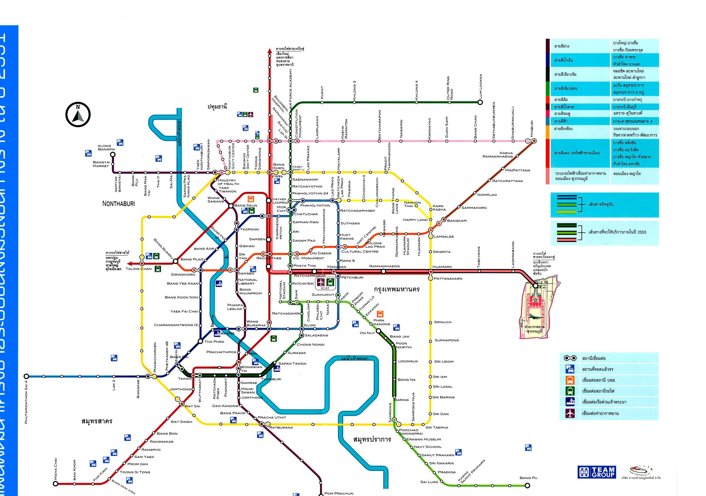
Here it is in all its glory. Click for MEGA SIZE.
Of course, considering it’s taken almost two years to finish the few kilometer extension from On Nut to Bearing, we may all be dead before we ever see this to fruition; as a comparison, China has been laying track (heh) like crazy and plans to have over 16,000 kilometers of high speed rail line down by 2020.
I also included a very rough collage of the map over an image from Google Earth to give an idea of scale:
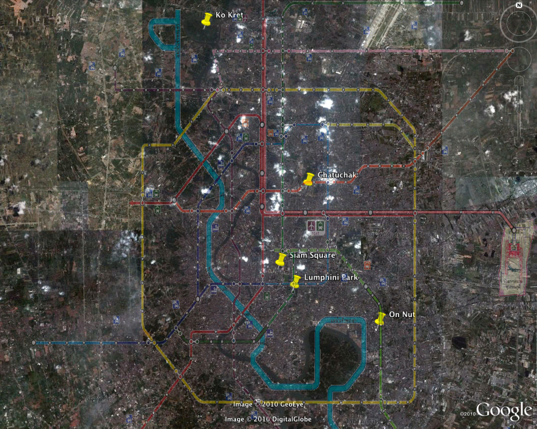
This picture is also embigginable.
At any rate, it’s exciting to think of what the future of Bangkok may hold. All they need now is to put in some bike lanes that aren’t used for parking by police cars, and we’ll be set.
Great work Greg. I hope that plan comes to fruition before Bangkok is lost to the seas.
Wow, a blog entry after my own heart.
Although it's unfortunate that Thailand takes forever to extend the current lines and forever to actually start new lines due to political problems, I'm glad they are starting to get the ball rolling on a few of the extensions and the new purple line as well as finally finishing the airport link. If Thailand had China's attitude towards mass transit (look at Beijing and Shanghai metros) maybe by now we would have seen a lot of these lines come into fruition.
Due to the lack of coverage by both the MTR and Skytrain, I can't help but feel like it's a novelty every time I take it since I always have to use a car to get there (either Mo Chit Station or Onnut or Phahon Yothin on the MTR) and then I take those down to Siam Square or somewhere else.
Still though, I'm really glad that Thailand has big plans for mass transit and that they are thinking about the future. Hopefully when these are built, Bangkok's traffic will only be limited to rush hour and not every hour of the day, lol.
That would be amazing to have all of those transporation options. I hope my grandkids can be there for the opening ceremonies.
Peter – yeah, the seas are getting closer… maybe they'll have to change the name to the MRTSCUBA in another 50 years.
Ben – That's a good point, I can see how it's seen as a bit of a novelty, especially if you live out of downtown. I do find though that by using the trains in tandem with other modes of transport can really reduce your travel time; although that's not the point, you're supposed to use only one mode. Anyway, it's a start, and maybe when things are done the mention of rush hour won't cause people to flinch. 🙂
Jay – I don't think you're too far off. 😛
This will be great when it is eventually done. Hopefully we can buy a house there before the lines are finished. I reckon we have at least 5 years.
I want to live near the 'Happy Land' station. Sounds awesome!
Wow! I hope I live to see the day this becomes a reality. That is seriously awesome!
@ Greg: Yeah, the relatives I stay with while I'm in Thailand live in Rangsit and I always look for news about the STR line that would supposedly go up to Rangsit and beyond but it seems like that line isn't a priority for the master plan yet. And as for your usage of public transportation in tandem to get around, what I usually do when I want to go to Siam for shopping from Rangsit, is ask my uncle for a ride to Future Mall, take one of those dedicated vans into a specific area (Central Lad Prao or Victory Monument), and then take the BTS or MTR/BTS down. When I go back I take the MTR, bus or dedicated van back to Future and then a taxi to my uncle's house. Needless to say, it's quite a journey every time (it takes roughly two hours+ total). But I don't expect mass transit station every block, a short bus ride to and from a close station is enough.
It would be totally awesome if Bangkok would end up like Tokyo. Tokyo is just the mother of all mass transit systems. With its commuter rail (frequent service), metro lines served by two different companies, monorails, private railways, it is very easy to get around and the idea of using any other mode of transportation doesn't even compute (at least when you're in the city, otherwise it's bus+/bike+ combo)
Thanks! What a great map. Its crazy to see how much the city has changed over the last decade.
Pie in the sky, most likely. Dont think the plans will make it to reality, at least in current version or like you say, in our life times. Shanghai now has 420 km of track freshly laid to meet demands of Expo (apparently, this makes it the longest in the world [find that hard to believe though in comparison to Tokyo's]). Now with Expo finished, they are redoubling efforts to go for another surge of development. And oh, yeah, the hi-speed trains are on track too – new 325 kph Shanghai-Nanjing opened this past July and new 375 kph Shanghai – Hangzhou this past Oct. The Shanghai-Beijing 400 plus kph scheduled to open in 2012 and another Shanghai – Hangzhou mag-lev 475 kph (built with Chinese tech btw) to open around the same time. By 2013 they will have completed 13,000 km of hi speed network – apparently more than the entire world combined. Seems that democracy definately NOT the preferred system for quickly modernizing developing countries….
Thanks for the info Hoffman, interesting to get some solid numbers. It's not just that China is doing more than everyone else, it's that they're DESTROYING everyone else. But like you say – I guess it's not a problem when you pretty much have to do what they say. The real shame here is the US, which should definitely have a high speed rail network (and Canada too, although our piddly population doesn't really make it financially feasible).
Ahh. one one my favorite Bangkok topics. I actually dig a Google map of what there is today. http://goo.gl/maps/PEYr
The latest "yet another grand transport plan" the very strange BRT has been fun to follow. At one point the whole project just stopped for no apparent reason, I almost thought that it would be another Hopewell. And they have grand plans of more lines. I will not try to predict if they will ever be built, using buses like trams in a very congested city seem very infective. But that the fun thing that there are artifacts left over from previous grand plans like the Hopewell pillars and the 2 bridges with room for rail left over from the Lavalin skytrain. Ok one of them are now used for a single track to the Chon Buri part of BTS. My take on why there are so many plans with incompatible equipment and different agencies that runs the different lines are that it creates a lot of jobs and makes a lot of tea money for different officials.
Wow, thanks DanishDave, that's a great map! Let me know if you update it to reflect ongoing construction.